• Exploring Earth
  • Photography

Derek Pickell

  • Exploring Earth
  • Photography

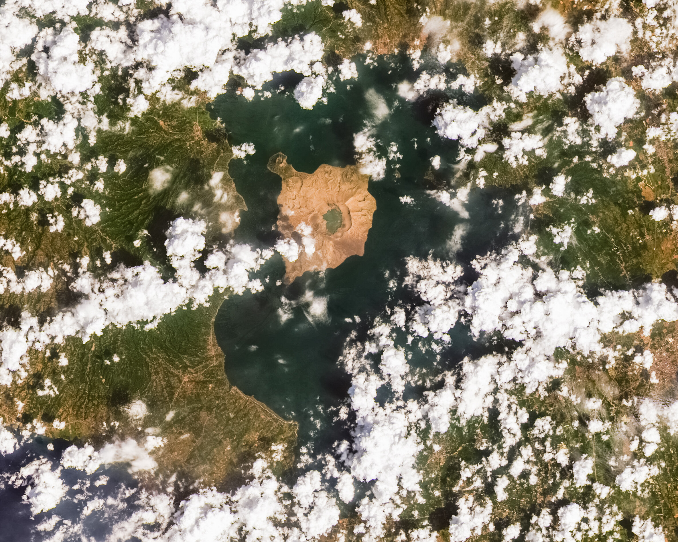
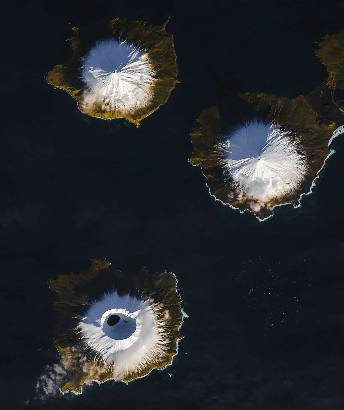
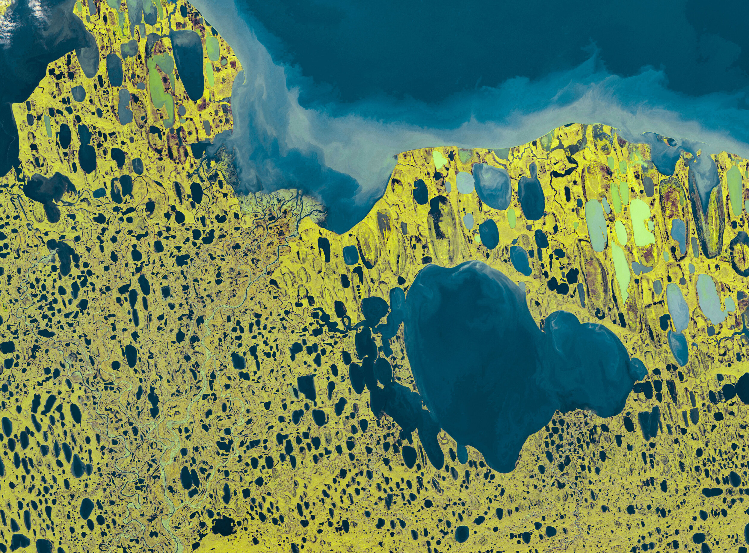
EXPLORING EARTH (FROM ABOVE & BELOW)

What started as a hobby during quarentine—processing satellite and telescope data to explore the world through pixels—has expanded into… well, not much more. Now I also write about my experiences in cold places and the moments in between.

Subscribe
Featured
IMG_2866.jpg
Dec 1, 2024
78° South
Dec 1, 2024

This is the South Pole Overland Traverse, day one, team of six, 78° South, a couple miles in, with many more to go…

Dec 1, 2024
IMG_3814.jpg
Feb 12, 2023
Polar Plunge
Feb 12, 2023

“Welcome to the void” said one of the current crew…

Feb 12, 2023
Above the Arctic Circle
Sep 16, 2022
Above the Arctic Circle
Sep 16, 2022

I now sit cliff-side above one of the most spectacular views in Greenland. Just out of reach, icebergs float through the Ilulissat Ice Fjord in such density…

Sep 16, 2022
GreenlandPart1.png
Feb 20, 2022
Mapping Greenland
Feb 20, 2022

Disko Island: the grooviest place name you’ve never heard of and the second largest island of Greenland…

Feb 20, 2022
LC08_L1TP_203045_20210923_20211003_02_T1.jpg
Oct 31, 2021
Shapes Part 1: Circles
Oct 31, 2021

To mix things up and make it interesting for me as I pore through satellite databases, I thought I’d give myself a challenge for the next several posts: find “geometric shapes” visible from space…

Oct 31, 2021
Illulisat-2.jpg
Apr 25, 2021
Abstract Arctic
Apr 25, 2021

Locked under ice most of the year, desolate, dark, sparsely populated: you could just as well be looking at the landscape of a recently discovered planet…

Apr 25, 2021
snapshot.jpeg
Aug 31, 2020
Caribbean Life and Hurricane Season
Aug 31, 2020

Hurricane Laura prior to landing on the Texas/Louisiana Border. Laura passed overhead here in Puerto Rico as a tropical storm several days prior…

Aug 31, 2020
LC08_L1TP_116050_20200311_20200325_01_T1.jpg
Jul 14, 2020
Philippine Eruption: Taal
Jul 14, 2020

This island within an island within an island is technically called a third-order (or recursive) island…

Jul 14, 2020
LC08_L1TP_20161116-3.jpg
Jun 28, 2020
Aleutian Volcanoes
Jun 28, 2020

On the Volcanic Explosivity Index (VEI), Okmok (the large caldera on the northeast corner of the island) rated as a 6 (of 8), or “Colossal”…

Jun 28, 2020
ShastaWestPic.jpg
Jun 23, 2020
Relief Mapping
Jun 23, 2020

The upper slopes of Mount Baker are cloaked in glaciers, which themselves are often covered in snow. Here, crevasses are much more apparent, which give light to how the glacier flows and deforms. Seracs, shearing, transverse crevasses, etc. are very easy to identify...

Jun 23, 2020
LC08_L1GT_060114_20190228_20190309_01_T2.jpg
Jun 13, 2020
Drygalski Ice Tongue
Jun 13, 2020

The Drygalski Ice Tongue is a ~4000 year old floating extension of the David Glacier near McMurdo Station in the Antarctic Ross Sea…

Jun 13, 2020
LC08_L1TP_004248_20190831_OUTPUT.jpg
Jun 8, 2020
How to Produce Beautiful Imagery of the Earth from Satellite Data (I made an app!)
Jun 8, 2020

I’ve spent some time put together an app you can download for free that bypasses the need for any fancy software, automatically merging different satellite bands, pan sharpening the image from 30m to 15m resolution, and adjusting the output for easy final color corrections in any basic image editing program…

Jun 8, 2020
The Valley of Death
May 29, 2020
The Valley of Death
May 29, 2020

Walk through the Mojave Desert, and you might become exhausted from the desolation and homogeneity of your surroundings. View it from above, and you will instead see a complex landscape formed by a variety of geological processes and carved by a seemingly scarce resource: water…

May 29, 2020
Rainier042320.jpg
May 22, 2020
Cascade Volcanoes
May 22, 2020

Drive to Crater Lake for clues of what the future may hold for some of these Cascade volcanoes. Like Mount St. Helens, the former volcano called Mount Mazama had a series of explosive eruptions (~7700 years ago) that led to the collapse of its upper slopes…

May 22, 2020
T43TDM_20200309T055649_TCI.jpg
May 12, 2020
Lake Baikal Thaw
May 12, 2020

Lake Baikal rules the worldly superlatives: deepest lake, largest by volume (contains ~20% of the world’s surface freshwater) and home of the only exclusively freshwater seal…

May 12, 2020
20200425-T37REJ_20191213T075229_TCI.jpg
May 8, 2020
Volcanoes of the Arabian Peninsula
May 8, 2020

From a scientific standpoint, it appears that these volcanoes are somewhat neglected, perhaps due to their inaccessibility (and I couldn’t even find a Wikipedia article if that means anything)…

May 8, 2020
20200425-T52KDA_20200330T013711_TCI-Pano.jpg
Apr 30, 2020
Ephemeral Australian Lakes
Apr 30, 2020

These images show just three of hundreds of ephemeral salt lakes scattered around the west and north of Australia. Only after monsoon rains do they fill…

Apr 30, 2020
MalaspinaGlacier270619
Apr 25, 2020
Malaspina Glacier
Apr 25, 2020

More expansive than the state of Rhode Island (~4000 square kilometers), this is the largest glacier of its kind in North America, and the largest non-polar piedmont glacier in the world…

Apr 25, 2020
20200406-T12SWH_20200404T175909_TCI.jpg
Apr 10, 2020
Canyonlands
Apr 10, 2020

Unlike other deserts across the world, one reason this area is not covered in sand dunes despite the high presence of erodible stone is due to cryptobiotic soil—a living crust composed of lichen, bacteria, cyanobacteria, algae and fungi…

Apr 10, 2020
T03VWL_20190707T222539_TCI-Pano copy.jpg
Apr 4, 2020
Yukon-Kuskokwim
Apr 4, 2020

To get a true sense of size, view the above image at full screen and search for the three active airstrips located within the delta fan…

Apr 4, 2020
20200329-T18QUL_20190326T154549_TCI_10m-Pano-Edit.jpg
Mar 31, 2020
TOTO
Mar 31, 2020

Here’s an image of an underwater landscape, with the shallow Bahama Banks fading away into the massive 2000m (6600ft) deep Tongue of the Ocean (TOTO) trench…

Mar 31, 2020
NGC4921.jpg
Mar 29, 2020
Hubble Data & Galaxy Names
Mar 29, 2020

In the 1700s, Charles Messier, a French astronomer, spent countless hours scanning the sky in search for comets. Given the limited optical technology of the time, he occasionally came across blurry objects that appeared similar to comets, yet remained fixed in the sky…

Mar 29, 2020
T21MTU_20190920T142041_TCI.jpg
Mar 27, 2020
Balbina
Mar 27, 2020

These unusual islands change in number from 1000 to over 3000 as the rainy season fluctuates water levels around 12m (40 feet)…

Mar 27, 2020
2019-09-28, Sentinel-2B L1C, script.jpg
Mar 24, 2020
More Lakes Than Land
Mar 24, 2020

It’s thought that the orientation of these parallel thermokarst (thaw) lakes near the shoreline is no coincidence. As winter turns to summer, the upper layers of ice melt, and areas that had particular weight in ice become depressed, allowing water to pool…

Mar 24, 2020
ChannelIslandsSeasons.jpg
Mar 22, 2020
Spring
Mar 22, 2020

Closer to the California coast, this island has a designated population of two people, yet is California’s largest island (three times the size of Manhattan). The longest sea cave in North America can be found here, along with island foxes…

Mar 22, 2020
NGC1097.jpg
Mar 21, 2020
Looking the Other Direction
Mar 21, 2020

The feeling of having access to the data from a 4.7 billion dollar instrument that has produced (with the ongoing help from thousands of scientists and engineers) some of the most groundbreaking and beautiful images of the universe gives me the shivers, and it almost feels like theft getting free access to nearly all of it…

Mar 21, 2020
2019-06-25, Sentinel-2B L1C - volcanoes, True Color.jpg
Mar 18, 2020
Erupting Volcanoes
Mar 18, 2020

I might have gone a little overboard with this one. But I love the idea that one can track down satellite imagery to see Earth’s active volcanoes in action, especially when some of these remote or brief eruptions are barely captured on the ground…

Mar 18, 2020
T04NFH_20181114T210441_TCI.jpg
Mar 17, 2020
South Pacific, Part 2
Mar 17, 2020

London, Paris, Poland, Banana. These are the town names on Kiritimati Atoll in Kiribati…

Mar 17, 2020
T06LXH_20200221T195849_TCI_10m.jpg
Mar 16, 2020
South Pacific, Part I
Mar 16, 2020

The South Pacific is a truly special place that I got a bit carried away exploring, to the point that I may need several posts to cover things I’ve come across…

Mar 16, 2020
L1C_T39QYC_A024470_20200228T065713copy.jpg
Mar 15, 2020
The Empty Quarter
Mar 15, 2020

These depressions are thought to have once been lakes, with hippopotamus fossils, among others, found here. Today, the Empty Quarter contains the largest expanse of sand dunes in the world…

Mar 15, 2020

Page 2

Featured
Lac Manicouagan (Copy)
Mar 2, 2020
Lac Manicouagan
Mar 2, 2020

Lac Manicouagan, Quebec, Canada. I stitched together a series of false color images from the Sentinel 2 satellite in order to produce this image, captured on August 2019…

Mar 2, 2020
Subscribe